Brits could be set for some scorching conditions as forecasts suggest the jet stream could "buckle". Netweather's latest forecast states that by the end of May, there could be signs we are heading into a "" beginning to June.
"There are hints that the jet stream could begin to buckle by May 30 and the Azores high build towards [southwest] England," said forecaster Jo Farrow. "This would interrupt the westerly unsettled flow and could herald a drier, sunnier weekend for the start of June." The jet stream impacts weather in , , and by influencing the movement and strength of weather systems, ultimately dictating whether we experience settled warm weather or unsettled, wetter conditions.
The explains: "Sometimes, like in a fast-moving river, the jet stream’s movement is very straight and smooth. However, its movement can buckle and loop, like a river’s meander. This will slow things up, making areas of low pressure move less predictably."
READ MORE:
READ MORE:
Sadly, hopes of a hot Bank Holiday weekend remain tempered. Ms Farrow added: “This Bank holiday weekend does look mixed with bands of rain, particularly at night, along with scattered showers.”
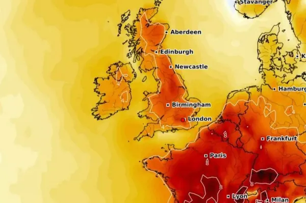
The following weekend could see temperatures begin to rise, however. Temperature anomaly maps suggest June 4 could bring much higher temperatures than normal for this time of year.
For the period of May 28 to June 6, the Met Office said there is most likely to be “changeable” weather with “further frontal systems running east into the UK bringing further spells of rain” and “showery interludes”. There are also signs strong winds could develop, particularly in the northwest.

Of a potential regional split in the weather, the Met Office said: “With time the signs are that systems will increasingly track to the northwest of the country, with the south starting to see longer, drier interludes while the northwest continues to see more in the way of rain and at times strong winds, temperatures are expected to be slightly above average overall, but will be cooler in any prolonged periods of rainfall.
"Meanwhile there is the possibility of some very warm, perhaps hot conditions developing, especially in the south and these bring with them the chance of thunderstorms.”
In its long range forecast for June 7 until June 21, the Met Office said there is likely to be “changeable weather across the UK” that has a “mixture of Atlantic weather systems moving in from the west interspersed with dry and sunny periods”. It said this will mean wetter conditions tending to be across the northwest of the UK, with the south and southeast likely to see more in the way of dry weather.
The forecast added: “Temperatures are most likely to be near normal or slightly above in the north and west, perhaps with some hot spells at times, especially across the south.”