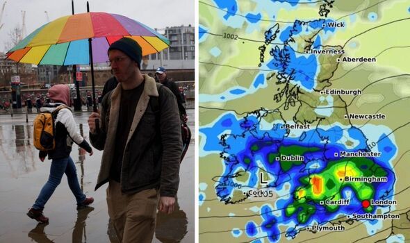
UK maps have suggested that much of the country is in for a drenching. WXCharts suggests that at 12pm tomorrow, rain will fall over pretty much all of southern England, except for Plymouth and the surrounding area, as well as the Isle of Wight, and Weymouth, Swanage and . Moreover, a section of will be dry at this time, it is expected, along with a tiny part of northern Wales.
The precipitation will stretch all the way up through the Midlands up to Manchester, charts suggest. The Lake District, Yorkshire Dales and places directly north of the city, such as Preston, Bradford, Huddersfield are covered in blue. As is Liverpool. Overall, much of northern England is set to be wetted. Most of Northern Ireland will also be rained on, it is thought, apart from a lot of the north of the country. A patch can also be seen in Scotland south of Edinburgh, as well as in the highlands and north western isles.
The Met Office says there is a 70% chance of rain in London on Tuesday at 12pm, and a 90% chance at up until 3pm.
After that, there is an 80% chance up to 5pm, 70% at 6pm and 60% at 7pm.
At 8pm, this decreases to 50%, with a 30% chance at 9pm and 10pm.
Earlier this day, there is a 90% chance of precipitation at 1am.
The weather service says that a spell of "heavy rain and strong winds" will spread across much of England and Wales, also affecting Northern Ireland for a time during the morning, on Tuesday.
Meanwhile, experts add, there will be "sunshine and showers in Scotland".
For Wednesday to Friday, the Met Office says: "Further spells of rain spreading in from the west at times, interspersed with sunny spells and scattered showers.
"Windy at times and temperatures around average for the time of year."
The longer range forecast, between May 30 and June 8, is "likely continuing changeable with further frontal systems running east into the UK bringing further spells of rain, with showery interludes in-between".
Experts add: "Strong winds may also develop at times, particularly in the north and northwest. With time the signs are that systems will increasingly track to the northwest of the country, with the south probably starting to see longer, drier interludes while the northwest continues to see more in the way of rain and at times strong winds.
"Temperatures are expected to be around normal overall, but will be cooler in any prolonged periods of rainfall. Meanwhile there is the possibility of some very warm, perhaps hot conditions developing, especially in the south and these bring with them the chance of thunderstorms."