Another burst of scorching summer weather is on the horizon for Brits as forecasters predict a second heatwave will sweep across the country in just days.
Temperatures are set to climb on Saturday, June 28, according to advanced weather modelling maps - which show a surge in heat spreading from the southeast upwards, bringing the mercury up to 30C in some areas. The southeast is expected to bear the brunt of the hot spell, with Essexforceast to be the warmest spot, hitting at least 27C by 6pm on Saturday. Nearby counties won't be far behind either. Cambridgeis set to reach at least 25C, Londonwill climb to 24C and Northampton should see temperatures of at least 23C. The warmest conditions will begin building steadily in the days leading up to the weekend, with dry air and sunshine dominating much of southern and central England.
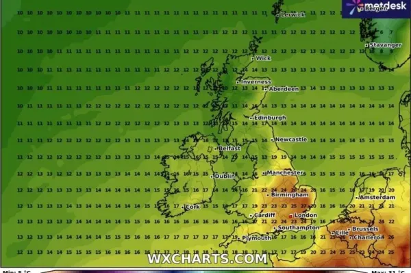
The Midlands can also expect a taste of summer, with Birmingham forecast to hit a minimum of 24C, Further north, the heat will fade slightly. Manchester is set to welcome cooler temperatures, hovering in the high teens by evening. In the northeast and northern England including Scotland, the shift will be more pronounced - with minimum temperatures there expected to stay in the mid-teens.
READ MORE: New UK law change for everyone who parks a car on a driveway - with added income boost
READ MORE: Exact date 'even hotter' heatwave to blast UK AGAIN with sweltering 34C highs
By Sunday at 6pm, the heatwave intensifies. Essex is forecast to climb to 29C, with Peterborough at 28C, London at 27C, and Kent close behind at 26C. Even Manchester will warm up, reaching a minimum of 24C, as the hot air spreads further north and west.
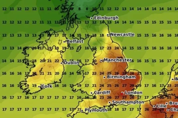
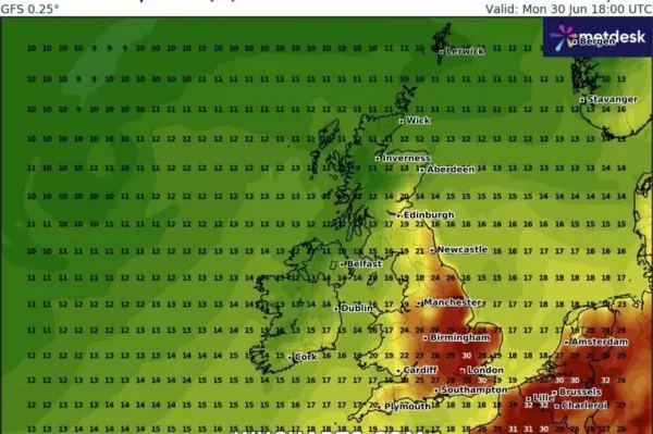
On Monday, the heatwave is expected to peak in the evening, with the hottest temperatures of the spell arriving just after the weekend. At 6pm, forecasters say parts of the southeast and east will hit a minimum of 30C - including Kent and Cambridge. London will sit just below, between 29-30C, while Southampton, Essex, and Birmingham are all expected to reach around 28C.
In its long-range forecast from Jun 27 until July 6, the Met Office says there's a chance of some occasional "very warm weather" - with south or southwesterly winds bringing brief bursts of hotter air. But this may be fairly short-lived - and could even be accompanied by a few thunderstorms at times, the forecaster warned.
It added: "Weather conditions are expected to be remain changeable through this period, as a series of Atlantic low pressure systems pass to the northwest of the UK.
"These will tend to bring some occasional rain or showers, most frequent in northwestern areas where it may also be rather breezy or windy at times. Whilst some rain or showers will be possible across the south and east, here longer drier spells are more likely, under the influence of higher pressure."