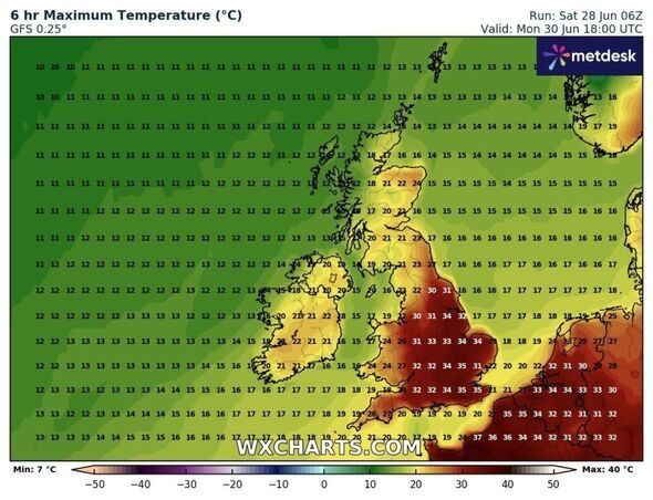
Weather maps show a brutal blast of heat reaching up to 35C ending with rain and possibly lightning in some parts of the UK. Maps generated on Saturday (June 28) by WX Charts show a north-south divide, with counties in the south of England, Midlands and East Anglia seeing top temperatures between 31C and 35C by 6pm on Monday (June 30). The south west and west Wales look set to feel cooler, with 19C-24C here. The north of Britain will be fresher too, with temperatures ranging from 22C in parts of Cumbria to 24C in north east Scotland, according to WX Charts.
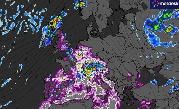
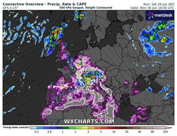
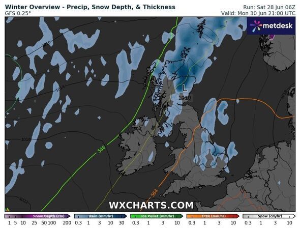
The maps also show a large band of rain covering almost the whole of Scotland and Northern Ireland by 6pm on Monday, while lightning looks possible over swathes of England and much of Wales. By 9pm, rain looks like it will be largely confined to parts of eastern England and the Midlands as well as Scotland, according to WX Charts.
While WX Charts' maps show lightning for some, the Met Office's five day forecast doesn't mention it. Instead, Monday will be hot and sunny for southern and eastern parts, but cloudier, breezier and rainy in the northwest.
Parts of the UK are already under an amber heat health alert. This includes London, the South East, East Midlands, South West and East of England.
The UK Health Security Agency has also issued a yellow alert for Yorkshire, Humber and the West Midlands to last until 6pm on Tuesday.
Met Office meteorologist Jonathan Vautrey said the big talking point at the moment is the rise in temperatures which parts of the country will see over the next few days.
He said north-west England, parts of Northern Ireland, and southern Scotland could see some rain on Saturday. Scotland will see average temperatures for the time of year, but across England it could hit between 29C and 30C in the south east.
On Sunday, temperatures will pick up. North-western Scotland may still see rain, but everywhere else will be warmer, with highs of 30-31C in the south east.
There will be a north-west and south-east split on Monday with a chance it will feel wetter and windier across the north west. The heat look set to remain across central and southern regions.
Temperatures here could reach 34C on Monday. Mr Vautrey said if this were to happen, then it would only be the fourth time in June since the 1930s.
The June record stands at 35.6C, recorded at Southampton Mayflower Park on June 28, 1976, and again at Camden Square, north London, on June 29, 1957. Mr Vautrey said there is a 20% chance it will reach that mark.
He added that Tuesday looks set to see the heat linger, with a maximum temperature of 34C possible, before it becomes cooler towards the mid-20s in the middle of next week.