Forecasters have revealed the exact date a wall of rain will bring an end to a summer sunny spell, drenching Brits across the country.
Brits were left sweltering in 35C heat as scorching conditions baked the countryover the past few days. But new weather maps from WXCharts shows a wall of rain headed toward the UK from today and into tomorrow.
Towns in England such as Gateshead, South Shields and Hexham are set to be buffeted by rain. Much of Northern Ireland and central and northern Scotland are also forecast to be drenched.
READ MORE: Devon beach horror as 1,000 injured in 'Jaws-like' incident as sea turns red from blood
READ MORE: The last words my poor Jack said were 'dad did this and he did it on purpose'
As much as 5mm is expected to fall near Inverness near Inverness by 9pm today, according to the WXCharts map. In western Scotland some 3mm per hour is set to be dumped. In North Yorkshire and the North East upward of 1mm per hour is forecast to fall.
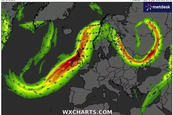
The rain will be carried by the jet stream that will race across Northern and Central parts of the UK from about 12am on July 1. WXCharts show the wind driving across the UK and into Scandinavia and Eastern Europe at a speed of 120 knots.
While many Brits will have delighted in the balmy temperatures, many will welcome the relief from the incoming rain. Rain will clear parts of Scotland tonight with clouds extending across northern England and Wales, dumping a little drizzle at times.
The Met Office added it would remain drier and clearer elsewhere with conditions remaining "very warm and muggy in the south and southeast." A Met Office spokesperson said of Tuesday's forecast: "Hot and muggy in the southeast with the odd heavy shower possible. Bright and fresh in the northwest. Elsewhere, rather cloudy with patchy light rain or drizzle over the hills."
The outlook for Wednesday to Friday continued: "Fresher for all, with cloudier skies bringing spells of rain, these sometimes heavy on Wednesday and Friday, but some drier, brighter intervals as well. Temperatures near or slightly above average."
The UK Health Security Agency (UKHSA) and the Met Office previously issued amber heat health alerts for five regions of England as well as yellow alerts for two regions. The alert, from 12cm June 27 will continue to 6pm on July 1.
The amber alerts affect the East Midlands, South East, South West, London and East of England. Meanwhile, Yorkshire and the Humber as well as the West Midlands fall under a yellow alert.
An amber alert means weather impacts are likely to be felt across the whole health service. A UKHSA spokesperson added that health impacts would likely be seen across the wider population.
It added there could be an increase in risk to health for individuals aged over 65 years or to those with pre-existing health conditions. Dr Agostinho Sousa, Head of Extreme Events and Health Protection at UKHSA, said: "We have already seen a spell of hot weather last week and temperatures are once again set to increase in the coming days, with central, southern and eastern areas of the country likely to see the biggest impacts.
Our findings show that heat, especially at the sort of temperatures we are likely to see at the beginning of next week, can result in serious health outcomes across the population, especially for older adults or those with pre-existing health conditions.
It is therefore important to check on friends, family and neighbours who are more vulnerable and to take sensible precautions while enjoying the sun."