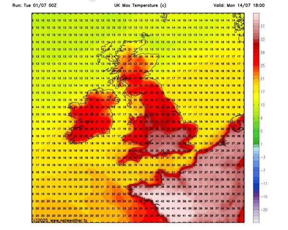
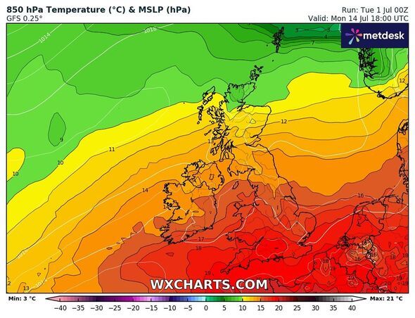
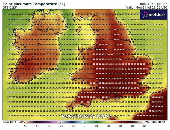
The UK could be blasted by hot weather conditions of up to 36C as the latest weather maps show an Iberian plume hitting the country bringing heatwaveconditions. Weather maps for July 14 show that parts of the UK will bake in scorching temperatures, with even the Scottish highlands sweltering at 25C.
The maps from WXCharts and Netweather.tv have turned dark red as they show the intensity of extreme weather. According to the weather maps, areas around London and Southampton are to be the most impacted, with the maximum temperatures oscillating between 35 and 36C. Other areas such as Manchester, Birmingham, Leeds, Stoke, Worcester and Luton will see highs of 32-33C, the maps have suggested.
The extreme predicted conditions come days after the Met Office warned of the possibility of 35C in one region of the UK on Tuesday (July 1). The UKHSA has extended the amber heat alert to more regions as it urged Brits to take extra care while stepping out of the house.
Under the Weather-Health Alert system, an amber warning indicates that weather-related effects are likely to impact the entire healthcare system. At this stage, some health effects may begin to emerge across the general population.
Individuals aged over 65 or those with existing health conditions-particularly respiratory or cardiovascular issues-may face an increased risk.
Met Office Chief Meteorologist, Paul Gundersen, said: "Tuesday will be another hot day, though the highest temperatures will be more confined to the south east of England where 35C is possible.
"Fresher air and some rainfall will move in from the west through the rest of the week, bringing an end to this heatwave, although many parts will remain dry and still see plenty of sunshine."
The Met Office's long-range forecast between July 5 and 14 reads: "Following a fine couple of days in the run up to this period, away from the far northwest where more persistent rain is expected to develop, a transition to something more unsettled countrywide looks likely.
"Cloud and rain associated with an Atlantic frontal system and area of low pressure is likely to sweep south and east, with rain always most persistent on western hills whilst some eastern areas in shelter could see warm and humid brighter breaks.
"Likely turning cooler and more showery later in the weekend and into next week, followed by a changeable pattern with further areas of cloud and rain and brighter, more settled spells in-between.
"Temperatures are likely to be around average overall, with an increasing chance of warmth in the south as the period progresses."