Following a week of cooler days, another heatwave is expected to hit parts of England next week, starting on Wednesday, July 9. The BBC Weather forecast predicts that in the capital, the heatwave will last for 11 days until Saturday, July 19. During this period, nine days would have temperatures above 30C, according tot he forecast.
According to the Met Office, a heatwave is defined as a period where daily maximum temperatures meet or exceed the heatwave threshold for three consecutive days. For London and the South East, the minimum is 28C, while 25C is the threshold for much of northern and western parts of the UK. If these conditions occur, it would be the third heatwave in the UK in under a month, following record-breaking temperatures in June and early July.
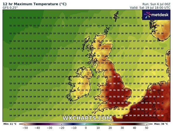
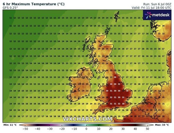
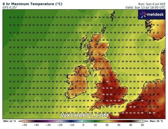
In London, BBC Weather forecast predicts that temperatures might rise to 32C during four consecutive days - July 11, July 12, July 13 and July 14. Weather maps generated on July 6 by WX Charts, which uses Met Desk data, further support this forecast. Latest maps show that on Friday, July 11, temperatures in London and South of England may fluctuate between 30C and 32C. Another chart for Sunday, July 13, predicts temperatures of around 29C in East Midlands and East of England, while London and South East are set to bake under up to 31C. If the predictions are correct, the heatwave will continue to Saturday, July 19. On this day, a WX Chart map shows that temperatures of 30C or more will heat up most parts of England, with a peak of 33C in the south.
Separately, Met Office meteorologist Zoe Hutin said: "Whilst it is difficult this far ahead to determine exactly how hot things could get next week and weekend, there is the potential that some parts of the country could reach heatwave criteria.
"Most likely it will be the south and east that see prolonged heat and thus could have another heatwave, but it is too soon to say exactly how high temperatures could get."
The Met Office's long range forecast from Thursday, July 10 to Saturday, July 19 reads: "A broad northwest/southeast split in the weather looks most likely through much of this period. Towards the northwest, Atlantic frontal systems will bring occasional rain and cloudier skies at times, along with breezier conditions, though there should be some drier, brighter interludes too.
"Further south and east, high pressure will likely dominate with a fair amount of dry and sunny weather to be had. With this, there is a signal for increasing heat and humidity and the potential for another period of hot weather to develop by the second weekend of July, probably lasting into the start of the following week. Given the anticipated high temperatures, the chance of thunderstorms also increases, though widespread rainfall across southern areas looks unlikely."