This week the mercury is going to skyrocket again, with temperatures in the low 30s predicted for the weekend, as per the Met Office. However, the good news is the heatwave, which is set to start on Wednesday or Thursday, will not be as fierce as steamy weather the UK experienced in June. That should mean cooler nights and not quite as sticky days.
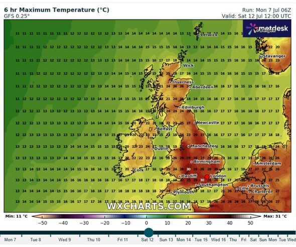
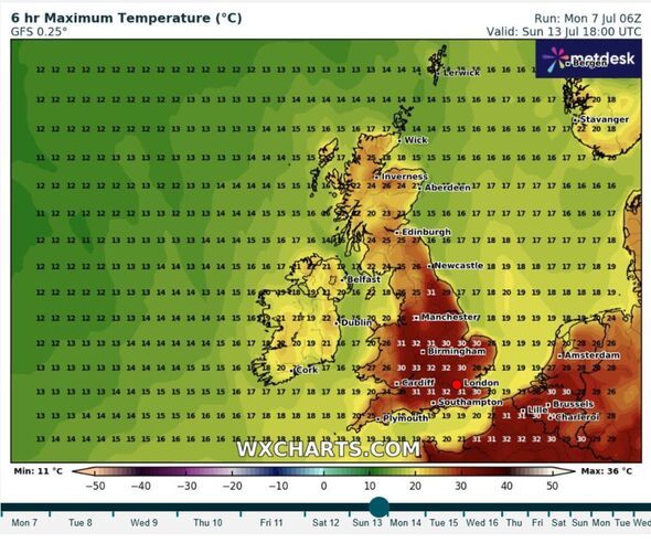
According to the Met Office, the UK's national forecaster, the temperatures could reach 32C by Friday. The warmest weather will be felt inland and heatwave conditions could be reached in Scotland, as well as Wales and England. Online forecaster WX Charts shares the Met Office's outlook. It's predicting a top temperature of 32C on Sunday, with 30C spotted in southern England on Saturday.
Last month's heatwave was so intense that the average temperature for the entire month was the highest on record for June, and the second-highest since 1884. Fortunately, this month's heatwave won't pack the same punch.
Deputy Chief Meteorologist Dan Holley explains: "High pressure from the Atlantic will gradually exert its influence over the UK this week. We'll see temperatures build day-on-day, with the potential for hot conditions to become quite widespread by the end of the week and into the weekend.
"On Wednesday, temperatures could reach up to 28°C in parts of England, climbing to 30°C on Thursday and 32°C by Friday. By this stage, heatwave criteria are likely to be met in parts of England and Wales, and in parts of Scotland over the weekend.
"High temperatures are likely to persist into the weekend, especially away from coasts with onshore winds, reaching the low 30s in portions of England and Wales, and accompanied by rising humidity and warmer nights.
"This heatwave is likely to last longer than previous ones so far this summer, and affect a wider area, with the focus for some of the highest temperatures displaced across more central and western areas at times. In addition, pollen and UV levels will also be very high in some areas."
 Today:
Sunny for many. However, cloud will move in across Northern Ireland and western Scotland as the day progresses, thick enough for some light rain and drizzle at times. A few showers may also graze some eastern coasts of England. Warmer.
Tonight:Cloud and drizzle likely across northwestern parts this evening and overnight. Dry elsewhere, with clear spells. A warmer night compared to of late.
Wednesday:Patchy rain and drizzle continuing across the northwest, otherwise a dry day for the rest of the UK with sunny spells. Warm for many, locally hot in the south.
Outlook for Thursday to Saturday:Dry and sunny for most, away from the far northwest where occasional rain or drizzle is still possible. Feeling hot and humid for many, by day and night.