Snow could lie as deep as 12 inches in part of the UK as weather maps show a huge swathe of the country blanketed with .
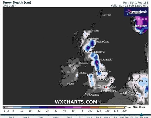
A generated on Sunday (February 2) shows snow as deep as 31cm (12 inches) over part of the Pennines at midday on February 16.
While the map shows that part of the UK seeing the deepest snow, much of Britain looks set for a dusting, according to WX Charts.
Some 15cm (5.9 inches) could be seen in the Cairngorms, 11cm (4.3 inches) in Northumberland National Park and 16cm (6.3 inches) north of Greater Manchester.
If the charts prove to be accurate this far out, then parts of North Wales might also see 10cm (3.9 inches) of snow depth, with areas in Lincolnshire under 6cm (2.3 inches) of snow, according to WX Charts.
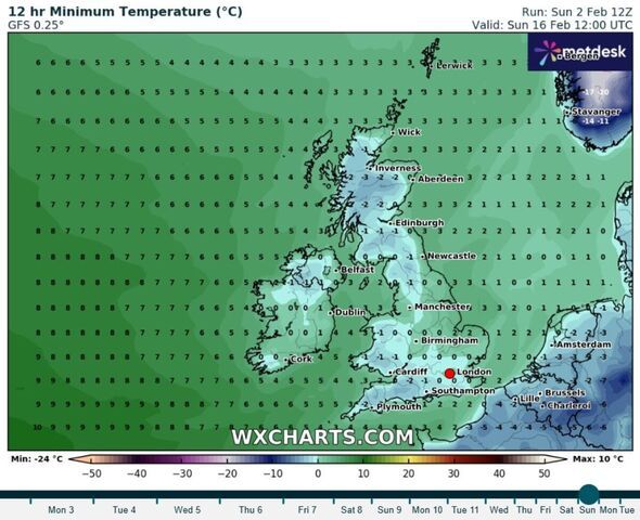
Weather maps show the mercury struggling to get much above freezing between now and February 16, with the whole country in a deep freeze for days.
Minimum temperatures look set to languish around 0C to 2C across much of the UK, but dipping into minus figures at times throughout the same period.
The Met Office's long-range forecast, covering February 7-16, suggests high pressure will be close to the UK over that period, leading to drier conditions and light winds in the south and east. These could result in overnight frost and fog, with temperatures slightly below normal.
According to the national forecaster, there is a "very low" chance that if the high positions itself in such a way as to result in a more easterly flow then "much colder" conditions could develop across the country, raising the spectre of wintry showers for some.
Netweather says the week beginning February 10 will see more unsettled conditions and possible gales. It adds that the south will stay "largely mild", while colder westerly and north-westerly winds may bring snow to areas in the north and especially over high ground.
But it likely won't be snowman-building weather for some as the forecaster says a significant build-up of snow at low altitudes is "unlikely".
 Met Office UK five day weather forecast
Sunday, February 2 - Thursday, February 6
Headline: Wet and windy in the northwest, but drier and rather cloudy elsewhere.
It will be murky and foggy with light rain on hills in the west, but a dry night for most. Under clear skies it will be chilly with a frost and patchy fog forming, mainly in the southeast. The northwest will turn wet and windy.
Monday will be increasingly windy in the northwest with rain spreading southeastwards. It looks to be more settled elsewhere, with the best of the sunshine across northern England and Wales. The southeast will turn cloudier.
Tuesday will be rather windy and mild with rain at times. The rain will be heavy in places. Generally, it will be dry on Wednesday and Thursday with sunny spells. It will turn colder though, with overnight frosts becoming widespread.